San Luis Obispo Half Marathon


Join San Luis Obispo Half Marathon
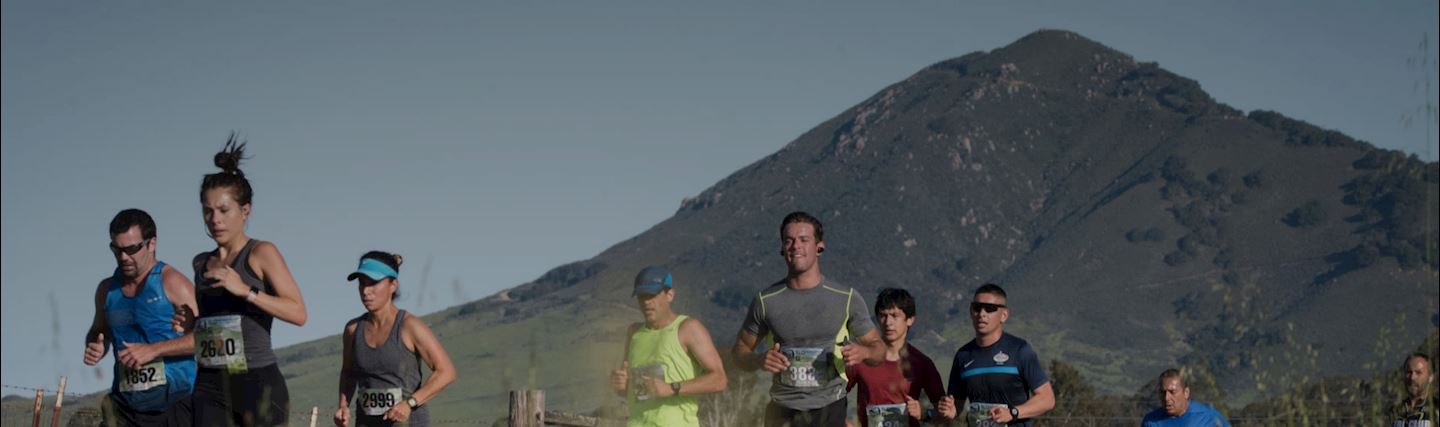
If you’ve ever taken a drive along California’s Highway 101, perhaps better known as the Pacific Coast Highway, then you’re probably familiar with the scenery you’ll find in towns like San Luis Obispo — huge, rolling green hills and mountains overlooking the rocky Pacific coastline, with bridges that span the canyons along the coast and wineries and vineyards tucked into the hills just beyond the edge of the land.The Annual San Luis Obispo Marathon, Half Marathon, 5K & Children’s Family Fitness Day races are a weekend long celebration on the magnificent California central coast. We welcome all levels of runners and walkers. Presented by LeftLaneSports.com, the weekend of events also benefit Jack’s Helping Hand and Bike SLO County.Enjoy one of the most beautiful courses in the nation as you run past our turn-of-the century downtown, the historic Mission San Luis Obispo de Tolosa, Victorian and California bungalows, the Chinese Garden, rolling vineyards and cattle farm land, run over the railroad square then finish at the iconic Madonna Inn. Perfect sunny coastal temperatures and first class #raceslo town hospitality awaits you.After we put that collectible cow bell medal around your neck, The “SLO Life Expo” awaits, offering the best of SLO County from handcrafted brews, world class wines, hometown BBQ, children’s activities and rockin’ music. Come see why we are the largest running event on the Central Coast and why SLO was voted a Top 10 National Destination and The Happiest Place in America.
–Saturday April 27th | Madonna Meadows
*Drop Bags open and festival grounds with bathrooms and water
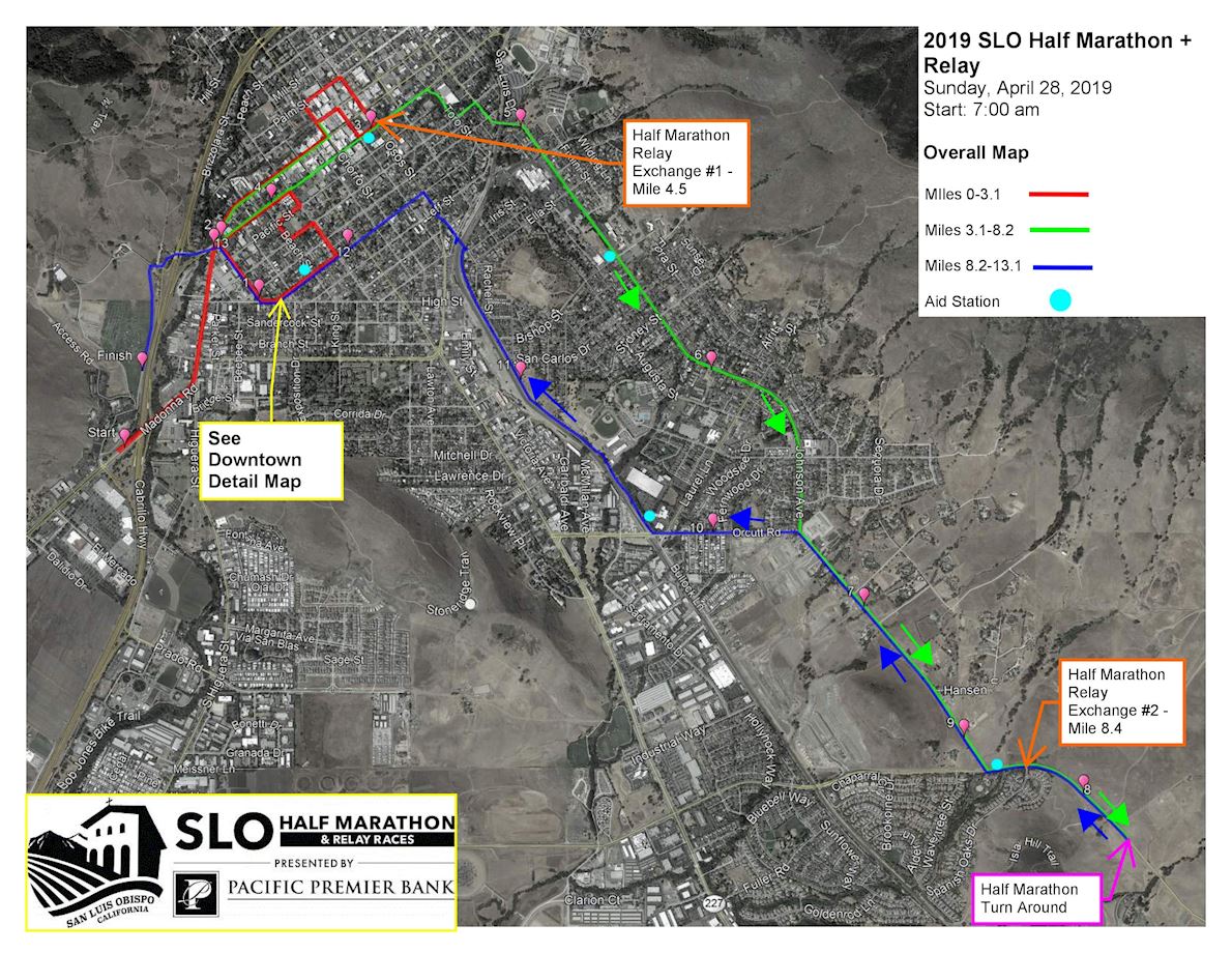
Course highlights
THE STARTOLD BOOT FENCE
Mile 4.5, runners make a slight left turn and head out toward the rural edge of town (look for the llamas, horses and the famous ‘old boot fence’ near Mile 5). This section (from mile 4.5 - 7) is the busiest portion of the course with two way runner traffic (in and outbound). Mile 4.5 to 5.5 has slight inclines and decline rollers. Just past Mile 5, A gentle descent into Islay Park and aid station will finish off this stretch of the course and allow you to see the next long climb of the day as you approach mile 6- Islay Hill- a shorter 0.4 mile stretch rising 80’ will put you in the busiest part of the course. Stay to the left through this section if you are a slower runner or walker.AVOCADO HILL & THE CLIF ZONE
Mile 6-7 is one big descent down the back of Islay Hill followed by one big ascent up Avocado Hill – roughly 60’ down and then 120’ up. The Clif Zone aid station (inflatable arch, tons of gel and music) awaits you at the top of Avocado Hill (which you will see and hear during your run up -it’s a loud party up there!). About ¼ mile past the Clif Zone, the half marathoners will turn around (it is well marked with timing mats) and head back the way they came, while the marathoners will continue on into the breathe taking Edna Valley.HALF MARATHON RETURN
Half marathon miles 7-9.5 are the exact return path from which they just came, for half marathon miles 9.5 to finish description see ** section below.MARATHON CONTINUATION
Runners continue along the two lane country roads over rollers until mile 8, just past the first winery of the day and then things flatten out for about a mile. Mile 9 starts a gradual 0.5 mile climb that descends into another aid station at mile 10. The run out to the marathon turnaround (mile 12.5) is relatively flat. A portion of this is an out and back, which is roughly 2 miles round trip. Out and back starts at Tiffany Ranch Road. Coming back from the turnaround (again, it’s a mile out and a mile back on the out and back), you will make a left turn and head across the valley into an undulating portion of the course ending in a small decline into an aid station near mile 14.5.BEAUTIFUL SLO TOWN HILLS
After a right hand turn, you’ll head up into 2 short, steep hills. Once those are complete, you’ll be able to catch your breath for about 0.5 miles on a gradual descent into another short steep hill at mile 16. This is the worst part of the marathon course; wide open vineyards, quiet, hilly, but really beautiful! Once you hit the aid station after the mile 16 hill, your legs get a rest as there is a 3 mile stretch of straight and flat roadway ahead with a couple of aid stations. **Marathoners overtake half marathoners at the half marathon turnaround (mile 7 half/mile 20.5 marathon- so beware of the crowds and stay to the right). Remaining description applies to both courses after mile 20.5 of marathon. Mile 19 is where the runners reconnect to the outbound portion of the route (mile 8.5 outbound). Miles 19-22.5 are a return of the outbound rolling hills section, back through the Clif Zone, down the long Avocado Hill and then back up the Islay hill and down into the Islay Park Aid station. (Miles 19-22.5 are the reverse of Miles 4.5-8.0). Hills hill and more hills here. Mile 22.5 starts a nice decent that lasts about 0.5 miles. Wide street, lots of room. Mile 23.5 -24.5: Runners leave the two lane country roads and access a 8’ foot paved bike path. This is the most crowded portion of the route (full of spectators as well as runners) as there are slow half marathon runners on the right side of the path and fast full marathon runners running up behind them on the left side of the path. Path is flat and fairly straight and follows the train tracks.EPIC VIEWS
At mile 24.5 (sorry runners:) there is a beautiful antique bridge over the railroad tracks & train station (the Jennifer Street bridge). The views up there are EPIC. The runners use the switchback handicap ramps (no stairs) to get up on the bridge itself, then come back down the opposite side ramps. A nice decent out of the ramps and back onto downtown City streets follows (and an aid station). Heavy spectator areas here to the finish.HOME STRETCH
Miles 24.5 - 25.9 are flat, fast and straight in closed neighborhood streets. The Madonna Mountain & below Finish Line are now in sight. Mile 25.9, runners go under a closed highway over crossing and climb a quick, short hill once again on a 8 foot bike path. The crest of the hill opens up to the fast downhill finish into the chute. Walkers or slow on right, fast on left.Route map
directions_runStart address: San Luis Obispo,us
flagFinish address: San Luis Obispo,us
Reviews
Be the first to write a review for this event
The race information has been found on the official website of the event or through publicly available sources. Always refer to the official website the latest race information. Please let us know if any data is wrong or missing, by emailing us.