
Join Grampians Peaks Trail 100 Miler 2026
The Grampians Peaks Trail (GPT), a world-class trail situated in Gariwerd, the Grampians National Park, spans 162 km with 7,700 meters of elevation from Mt Zero in the north to Dunkeld in the south. The GPT winds through the rugged, stunning, and varied terrain that makes the Grampians famous.
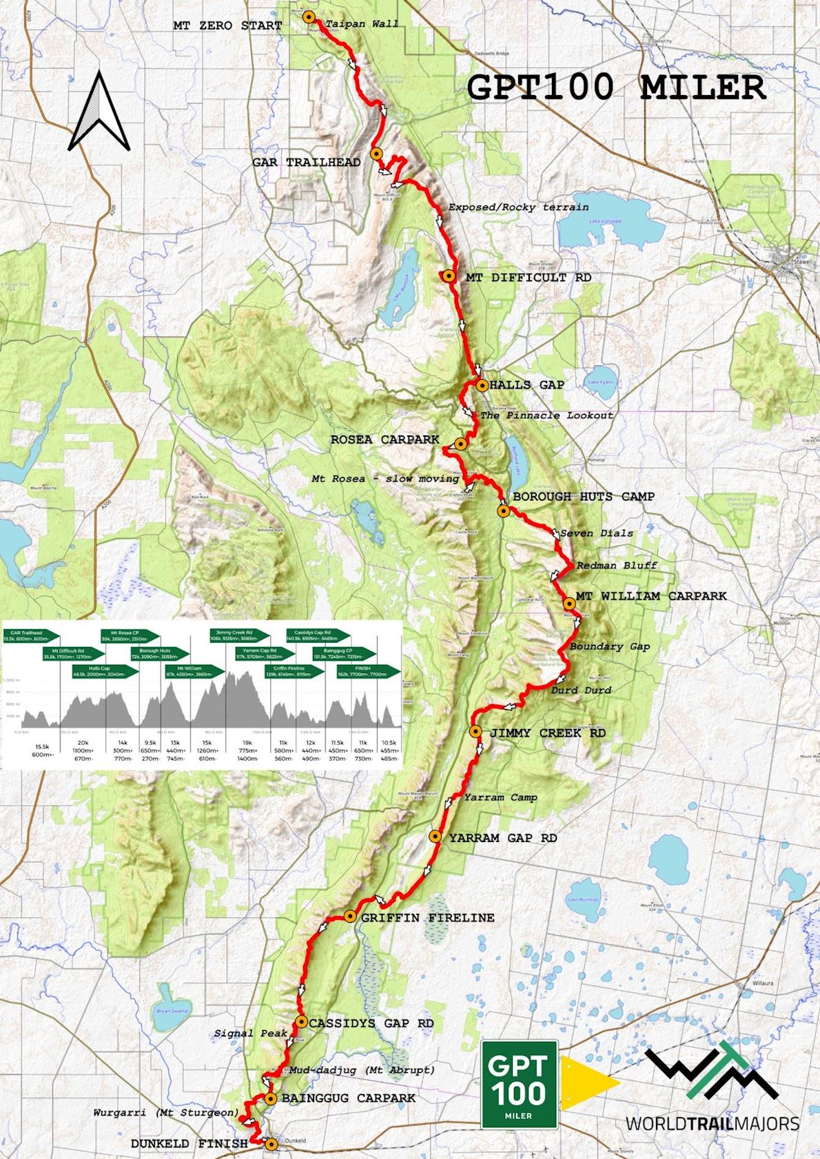
The race is divided into four sections, each with major aid stations. Much of the journey traverses remote wilderness areas, where the rocky GPT trail provides a welcomed sense of safety. Runners experience a deep connection to nature and place.
The central township of Halls Gap, just a three-hour (260 km) drive northwest of Melbourne, serves as the event's basecamp and headquarters.
The GPT 100 Miler is designed for trail runners seeking to accomplish, achieve, and experience the best of Australian wilderness.
Course details
There are numerous waterfalls for the next few miles before beginning the long and ever changing climb to GAR/Mt Difficult itself. Most of this long and exposed section has continual 360 views of the entire Grampians grandeur, which is a common theme throughout the whole run. Runners don’t actually summit GAR but rather turn to descend a very technical and choppy trail.
Once climbing again the trail goes between smooth and runnable to very rocky and uneven as it climbs ever so slowly and endlessly to Mt Difficult Rd aid station. This section will challenge every runner’s will. Take extra care of yourself through here.
The section from here to Halls Gap is relatively faster than the previous. However it does start with a slower climb, grinding up to Wartook Lookout. Once here, stop, soak in the view of the four lakes and surrounding Peaks. The course then follows a mostly smooth trail on a long descent to Halls Gap. Once turning left at Chatauqua Peak the 50k runners can see the finish. Runners take an enjoyable trail through the arboretum and caravan park to the town centre of Halls Gap. The 50k runners can celebrate; the Stage Race runners can be proud to have gotten through day 1; and the Miler runner’s journey has only just begun!
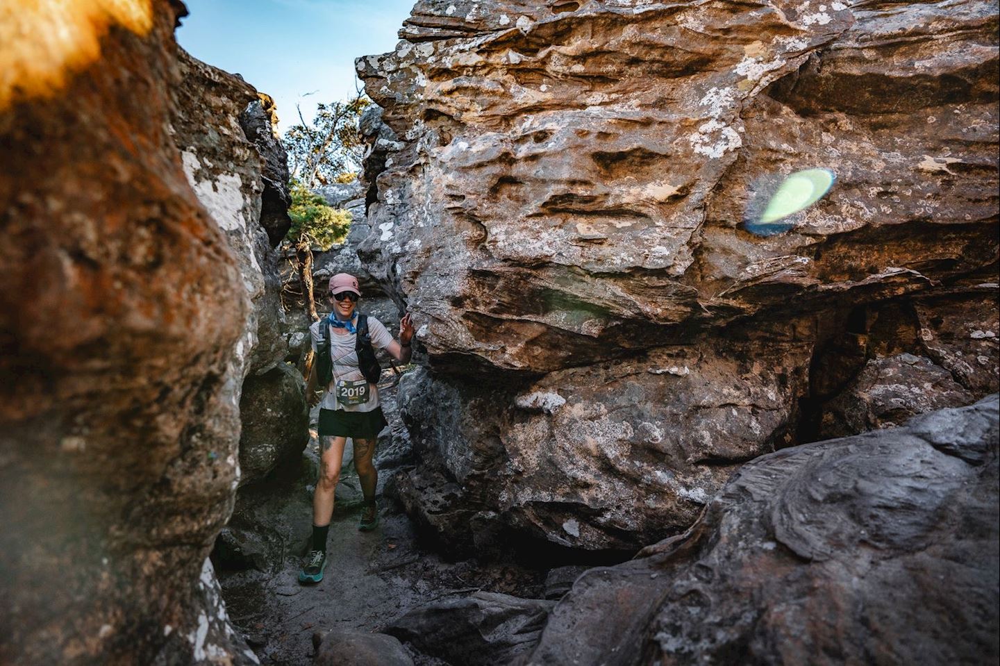
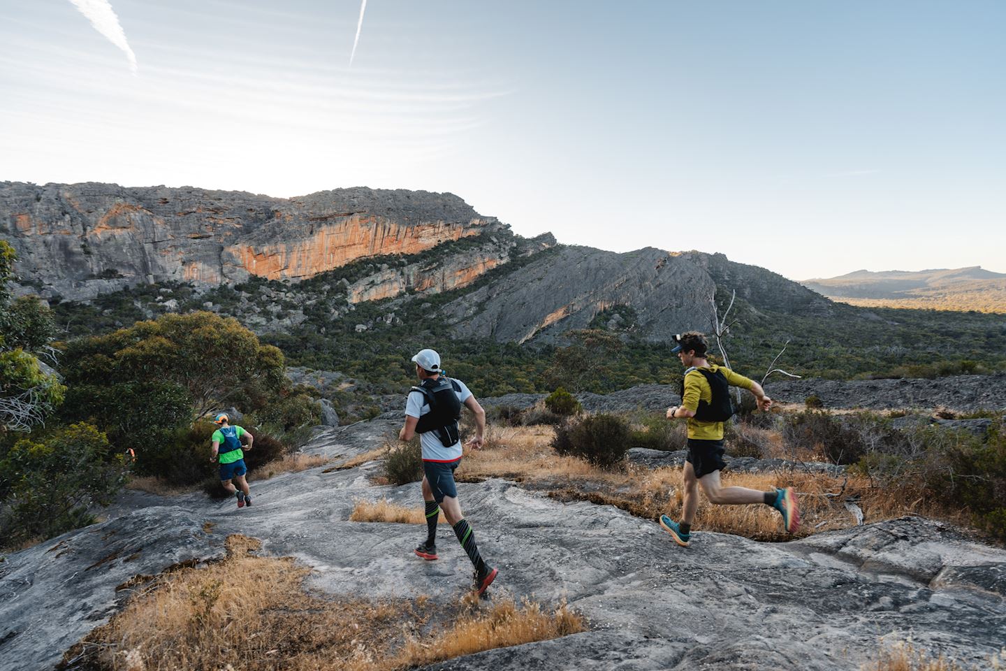
The course follows the Wonderland Trail through to the Grand Canyon Trail and up to the famous Pinnacles Lookout. From here, it continues along a technical rocky trail, with some ducking and weaving to Rosea car park aid station. This quick pitstop will be critical before tackling the climb up to Mount Rosea, and then traversing along the top, past some cliff edges and a scrambling descent. Just before you'll begin to tire of the technicality, the trail opens up to an 8km flowy descent, which is soft underfoot and all downhill to Borough Huts aid station. Take your time to replenish here as the next section through to Jimmy Creek Rd is the crux of the Grampians Peaks Trail.
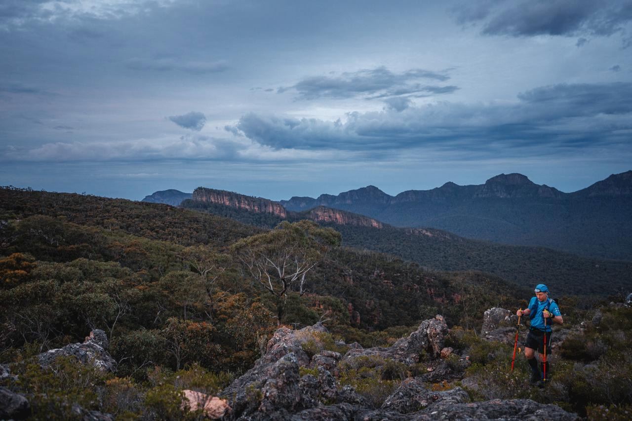
Beginning with a flattish mile or so after crossing the Grampians Road, the trail turns upwards for a long climb on a rock slab to the Seven Dials. This is an incredibly scenic climb with big views in every direction. From here there is another scrambling rocky traverse across the dials before dropping back down into the valley between the Seven Dials and Redman's Bluff on a loose trail. The climb to Redman's Bluff is much like the one before it. You can get very hot. It may be a long time since you've been at an aid station and the sun can heat the rock slab. Once again at the top, there is a rocky traverse and downhill to where you come very close to the road. From here, there is still a solid climb to the Mount William Road aid station along a steep trail.
After leaving the aid station, you complete the only paved section of the course, which is the road to the summit of Mount William. The walk up this smooth road is quite a treat for the feet. At the Summit, you turn back onto a trail and begin the long uneven descent to Boundary Gap, the saddle between Mount William and Durd Durd. After this there is the steepest climb on the entire trail. It is a stepped climb up to Durd Durd (Major Mitchell Plateau). This is truly where you might feel you are at your limit, but push through, because you are at the crux. After this climb the trail runs along the Plateau to the high point of the race, Durd Durd, at 1167m asl. From here there is a very very long continuous descent to Jimmy Creek Rd which starts out going over the top of Banksia Hill and immediately very steep down a loose goat track and then flattens out onto a well made wide trail.
From Jimmy Creek Rd aid station there is a beautiful gradual climb up an idyllic valley. From the top it gets rocky again; you begin to feel like you are really in the heart of nowhere, and the trail is a welcome sense of comfort. Eventually the trail hits a boulder field and it is very slow going and tiresome. But it doesn't last long, and soon you'll be at Yarram Campground. Be respectful to campers and marvel at the beauty of the place as you pass through. There is a buttery, smooth trail that descends from here to Yarram Gap Road aid station (with some tiny climbs along the way!).
The next section to Griffin Fireline and onto Cassidys Gap Rd is a series of shorter climbs and descents on newly made trails. You will even pass through some large fields around Wannon Camp and run a stretch of boardwalks across the flood plains. This is one of the fewer sections where clicking off the kilometres comes easy. There is an extended climb out of Griffin Fireline aid station, but the views are gorgeous and there are no steeper pitches. There is a nice rolling trail from the top all the way to Cassidys Gap aid station.
From Cassidys is the final big test, the climbs of Signal Peak and Mt Abrupt (Mud-Dadjug). These are two big mountains that can be seen from Mt William. They stand out and the climbs up them on mostly stepped trails are very challenging on tired legs. Take in the view from the summit of Mud-Dadjug as it is one of the finest points along the GPT. The descent is hard and choppy, often along big rock slabs to Bainggug Car Park aid station.
Here you know you will make it, but there are still two smaller climbs standing in the way. Get over the Bainggug rise and stumble up the final ascent to Mount Sturgeon/Wurgarri. It feels as though you can almost touch Dunkeld from the top. There are only 6km to go down a lovely descent and through open grassy fields. The trail follows the river right to the middle of the town of Dunkeld where only a couple hundred metres up Sterling St will bring you to the iconic finish line in the gardens of the terminus of the Grampians Peaks Trail.
Start address: Mount Zero, Laharum VIC, Australia
Finish address: Mount Zero, Laharum VIC, Australia
Route map
Register
Registration closes on 30 October (113 days left)
The current price step is valid until 08 October, 2026
selected tickets
Total
You can, within 24 hours after your registration, get a full refund if you change your mind.
We accept


![]()


![]()


![]()
What’s included
-
done Finisher medal
-
done Finisher’s T-shirts info
-
done Cash prizes
-
done Timing chip (single use)
-
done Shuttle to Start Line info
-
done Drink Stations
-
done Nutrition Stations
-
done Medical Assistance
-
done Bag drop
Reviews
Be the first to write a review for this event
Frequently asked questions
When and where can I collect my BIB/race pack?
- Location: 115 Grampians Rd, Halls Gap VIC 3381 1) Wednesday November 4, 2026 - 10:00 AM - 3:00 PM - Mandatory Gear Check, Bib collection and tracker allocation for Stage Race and GPT50k. GPT100 Miler. - 6:30 PM - 8:00 PM - Mandatory Gear Check, Bib collection and tracker allocation for Stage Race and GPT50k. 2) Thursday November 5, 2026 - 12:00 PM - 4:00 PM - Mandatory Gear Check and Bib collection for GPT100 Miler. 3) Sunday November 8, 2026 - 6:30 AM - Bib collection Opens for the GPT100 Dunkeld Trail Races at the Information Centre on Sterling St in Dunkeld.
What is the cancellation/refund policy for this event?
Force Majeure: If the event is canceled or postponed due to factors outside the organizer's control (e.g., wild weather, natural disasters, pandemics, or changes in law): The organizer will try to postpone or alter the event rather than cancel. No Guarantee of Refund: Full or partial refunds, credits, or fee exchanges may be provided at the organizer's discretion, but are not guaranteed. Cost Deduction: Any refund or credit provided may have reasonable administrative costs deducted. No transfer. No resell.
Do I need to carry all my mandatory gear the whole race?
YES! Simple, everyone who is running on one of our course must be carrying the entire list of Mandatory Gear with them at all times. There will be random check along the course and at the finish line with time penalties applying.
Are poles allowed?
Yes! You can use poles in any race, just be very mindful of how you use them and careful not to poke anyone. If you could please not use them early in the race or when the trail congestion is very tight.
The race information has been found on the official website of the event or through publicly available sources. Always refer to the official website the latest race information. Please let us know if any data is wrong or missing, by emailing us.
