Golden Leaf Half Marathon


Join Golden Leaf Half Marathon
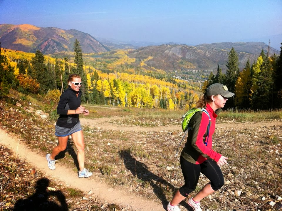
Timed to start runners off just as fall is arriving on the leaves, trees and slopes of these Rocky Mountain ski resort towns just west of Denver, the Golden Leaf Half Marathon takes runners on a point-to-point course that starts in Snowmass Village and finishes in Aspen, for a race that has been lauded by the likes of Colorado Runner and Trail Runner magazines as one of the country’s most scenic trail races.
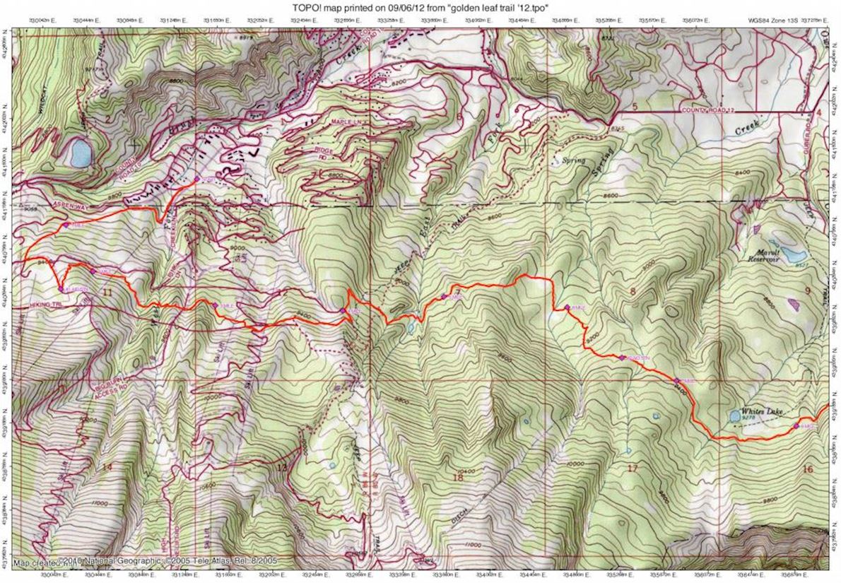
Several hundred runners crossed the finish line every year, a jump up from the previous years when a few hundred finishers completed the 13.1-mile trek across the trails and mountain roads between the starting line on Fanny Hill in Snowmass Village — which lies at an elevation of just over 8,600 feet above sea level — all the way to the finish line at Aspen’s Koch Park, at the intersection of Garmisch Street and West Cooper Avenue.
Because it’s run at such a high elevation and because it incorporates a number of technical and challenging trails, the race will definitely challenge most runners who attempts it — especially those who aren’t used to the altitude, which one runner noted caused several participants to struggle with the climbs, especially in the early going. There are also plentiful hazards along the course, with loose rocks and possibly muddy areas, depending on the weather leading up to the event as well as the day of the race.
You also get a sense that this is a race for the hardiest of runners when it has been cancelled only once in its more than three-decade-long history, in 2006 for a heavy snowstorm that socked the Aspen and Snowmass area.
Course highlights
The Golden Leaf starts on Fanny Hill just off the pedestrian mall in Snowmass Village at an elevation of about 8650ft. The course climbs up a ski area access road about 400 yards to a large maintenance building where the road splits. You will take the road that wraps around behind the building (going to the right). The road is fairly flat here for a few hundred yards. You will then turn left (just after passing a small beige building also on the left) onto a service road that goes up the Dawdler ski run. The uphill grind continues here. Continue climbing Dawdler to a 4-way intersection and take a left. Follow this road a couple hundred yards to a pond where there is a fork in the road. Take the right fork (the pond will be on your left) & ascend to the 1st aid station at about 1.63 miles (elevation approx. 9465 ft). The Government Trail intersects the road at this point. The West Government Trail was permanently realigned on the Snowmass Ski Area a few years ago. The Golden Leaf will be following this new alignment. The trail turn-off (and the hydration station) will now cut off about two hundred yards before the old turn-off and hydration station. The trail is still to the left (east). It follows a well cut and marked trail (called, again, Government Trail) until it meets the old trail just before the broken down footbridge that was at the old two mile mark.
The Government Trail is a single track that contours the mountainsides between Snowmass & Buttermilk before descending to the outskirts of Aspen. The trail is dirt with some obstacles (rocks, roots, etc.) and the terrain is hilly aspen forests & meadows. The 1st section is a rolling descent across Snowmass Ski Area. At about 3.25 miles, the trail merges w/a dirt road (Alpine Springs work road). Proceed downhill on this road and look for the trail to your right after 100 yards. Shortly, you will make a steady 100yd climb up a ski run to an abandoned work road. Follow this road to the left and slightly downhill until you intersect Elk Camp Road (approx. 4 miles). Turn left and go downhill on the road until you hit the Government Trail turn-off to the right. Take this to the right and you will be on the old race course alignment again. There are many signs and maps here. The course then continues on as it has in the past.
It goes down a long gradual hill to a meadow. Soon you will exit the ski area. There is a significant hill climb of about 300 ft. just before the Second Hydration Station (6.5 Miles, elevation approx. 9360 ft). Following the aid station, you are rewarded w/ some relatively flat to declining terrain.
The next landmark is a Forest Service gate (just after 8 miles) followed by a very rocky flat section. Subsequently, the course begins a gradual descent across Buttermilk and then the trail begins an extended steeper descent into Maroon Creek. One section of the downhill is a power line cut followed by an intersection with a service road. Abandon the trail and follow the road for about 400 yards, even though the trail falls steeply off to the left. The third hydration station (10.5 miles) is on this short road section. The trail from the aid station diagonals across the ski slope following first a double track then a single track until it leaves the eastern margin of the ski area. The trail then winds down to the Tiehack road which is followed to the north until taking a hard right onto the Terral-Wade bridge. After crossing the bridge the route leaves the asphalt, taking a trail to the left (thru the Moore Property). After about a mile running in the sage the route leads out onto the Maroon Creek Pedestrian bridge, takes a left onto the bike path and takes the next left onto the Castle Creek Pedestrian bridge. On the path leaving the bridge where it takes a hard left the route takes a hard right instead. Follow a single track by a pond on the right. The path goes left here and diagonals to the community garden across the parapet/hanglider landing zone. The route goes right where the access to the garden is on the left and follows double tracks to the bike path leading over the Marolt bridge. Taking a left off of the bridge onto 7th street the route leads to Hopkins Ave. where it follows the adjacent bike path a few blocks until the turn up to Little Cloud Park. After taking this turn, a hard left is taken onto the dirt path on the old train right of way. The path is followed a few hundred yards to the finish line.
PLEASE NOTE – there may be changes to the course based on ski area maintenance and USFS requirements. Please check back 3 weeks prior to the race.
Mappa del percorso
directions_runStart address: Aspen,us
flagFinish address: Aspen,us
Recensioni
Puoi essere il primo a scrivere una recensione per questo evento
Le informazioni sulla gara provengono dal sito ufficiale dell'evento o da fonti pubblicamente reperibili. Consulta sempre il sito web ufficiale per le ultime informazioni sulla gara. Informaci tramite email. se alcuni dati sono errati o mancanti.