Angeles Crest 100 Mile Endurance Run

03 ago 2019 (Sat)

directions_run

Ultramaratona - 0km

Angeles Crest 100 Mile Endurance Run

schedule Annullamento del biglietto 24h

local_activity Offerte e sconti

verified_user Refundable Booking

Join Angeles Crest 100 Mile Endurance Run

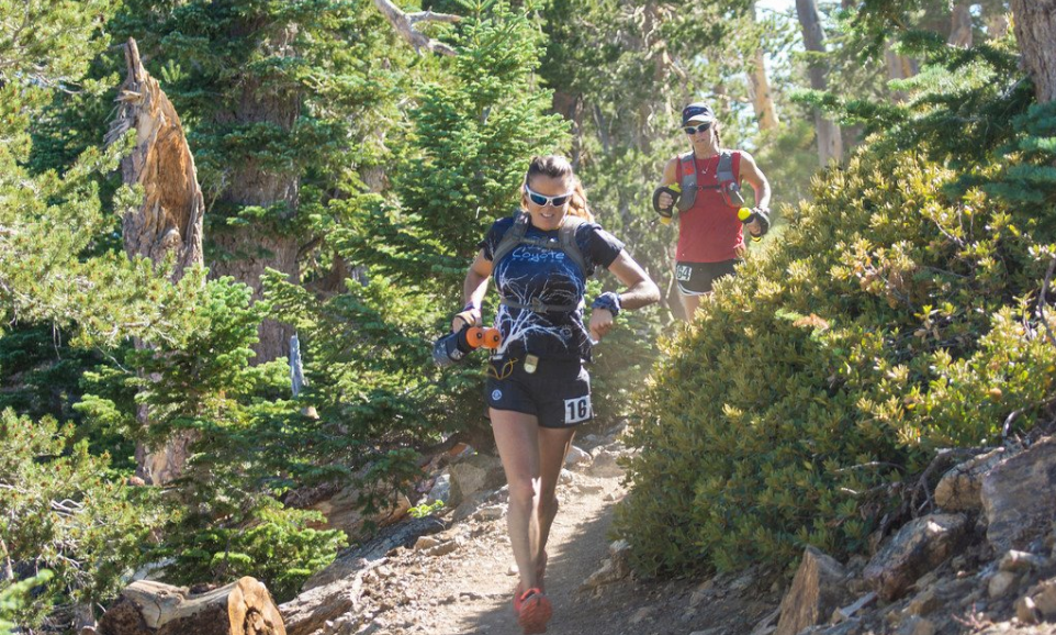
The San Gabriel back country retains much of the natural beauty, if not the primitive wilderness of yesteryear.Those desiring to see much of this primitive wilderness in a single day are invited to participate in the Angeles Crest 100 Mile Endurance Run.

The race is remarkably true to the original course laid out by Del Beaudoin in 1986 although minor revisions have been made. The trail travels through trees and shrub over dirt and even the open sandy terrain.

This is a true nature run and runners are invited to race and interact with nature!
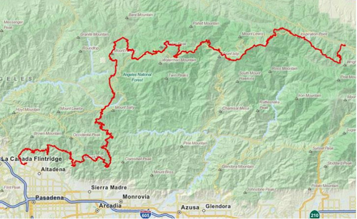

Course highlights

The AC100 runner enters Big Santa Anita Canyon at Newcomb’s Saddle, the 68 mile point on the course. Sturtevant
Camp, one of the more popular San Gabriel Mountain resorts during the Great Hiking Era (1895-1938), is 2.5 miles from
Newcomb’s Saddle.The AC100 Trail leaves Wrightwood via Acorn Street, climbing a steep grade, past the MariaStella camp on the left. At road’s end, the Acorn Trail is a left turn, where it begins its switchback climbing up 2.8 trail miles to the Pacific Crest Trail. At the PCT junction, the course turns right on the PCT. From here, the runner is treated to a panorama of Mt Baldy (10,760’) on the left to Mt Baden-Powell (9,400’) to the right. The trail stays mainly on the Blue Ridge, skirting the Mountain High Ski Areas, until it descends to the notch at Lightning Ridge’s to Inspiration Point. Inspiration Point is set up in the large parking lot with an adjacent toilet.

The runner leaves the parking lot on the PCT trail and soon passes the Grassy Hollow Visitor Center. Keeping to the trails marked with the white steel posts and the PCT badge, Vincent Gap is 4.5 miles west after Lightning Ridge. Vincent Gap is a PCT Trail head, with a large parking lot and adjacent toilet. The course then heads up the trail toward Mt. Williamson (8,214’) to a saddle that is within 300 feet of the peak. From the saddle, you can get a nice view of Eagle’s Roost and Twin Peak. The trail then heads down Williamson to Eagle’s Roost.

At Eagle’s Roost the course follows Hwy 2 from Eagle’s Roost to Buckhorn Campground, then north (down) to the Pacific Crest Trail. This detour on Hwy 2 is due to a closure of the Yellow Legged Frog habitat. The race follows the Burkhardt Trail for 1 ½ miles down to the PCT in the middle of Cooper Canyon, left to Cooper Canyon Campground, right turn from road/trail continues on PCT uphill, and back down to another road crossing of the access road.

From Cloudburst Summit the course follows a gentle downhill grade and runs parallel to the Angeles Crest Highway by several springs and past Camp Glenwood (mile 41.25) until Three Points (mile 42.72), which has a toilet. From Three Points, the AC100 course leads to a cut-off trail just before Sulfur Springs Campground. Turning leftwards over the ridge, trail contours around the ridge, dropping down to cross the drainage The course turns left on the paved road (5N04) northbound. Follow the road as it winds gently up to Alder Saddle, the intersection of road 3N17. Continue climbing leftwards up the exposed blacktop on Road 3N17.

The Mt Hillyer Aid-Station is located at the top of the climb. Bear right between a set of sawed-off telephone poles set into the ground. The trail travels through trees and shrub over dirt and then open sandy terrain.
The unsigned Mt Hillyer trail ascends a slight grade, then makes a switchback up and over the knoll-like summit. The trail contours through and then descends through large sandstone boulder formations. This portion of the course is well marked. The trail winds and then descends through large sandstone boulder formations to the Horse Flats Campground on the left side of a ridge. The Silver Moccasin Trail is rejoined at the Horse Flats Campground. From there it is about 1 ½ miles to the Chilao Visitor Center area. Turn left when the trail intersects with the single-lane paved road. Continue ½ mile past the large, tall conifer in the middle of the road. The Chilao Checkpoint will be located at the first “T” intersection to your right. Water is usually
available via tap at the picnic area. Turn right, staying on the blacktop and pick up the trail to the right of the rest rooms and picnic area.

The course continues up a ridge towards Chilao Campground on the Silver Moccasin Trail. Crossing the blacktop, it skirts the campgrounds to the right. Continue down about 1/2 mile where the trail connects to a dirt road. Bear left. This dirt road is a rolling climb up to the Charlton Flats blacktop access road. Bear left. You will pass through an open wooded area, with the sad remains of an incinerated vintage wooden building on the left. At a picnic clearing right after a USFS pipe-gate, the trail is visible - but not obvious - off to the right. The course may be re-routed during the race due to fire damage and Purple Poodle Dog Bush encroachment.Contour up the slope. At the Vetter Mtn/ Silver Moccasin trail junction, bear left. The Silver Moccasin trail contours along a wooded slope with picnic tables scattered under the trees. Following the NFS trail-markings, you will be contouring across a blacktop road up to the ridge. This part of the trail is obvious and there are no turnoffs.

The trail resumes on the other side of Highway 2. Follow the NFS trail-wands for a short distance, then bear left on the dirt road 2N23. Follow this road down into West Fork. Cross the “concrete bridge”, and start the long climb up to Newcomb’s Saddle. It is a long 2.5 miles to the top. At the pipe-gate, turn right on Road 2N24. Run for .4 miles, bear left at the next “Y”. The aid-station is on the southfacing side of the ridge, and you won’t see it until you are right on top of it. About 100’ past the Checkpoint, the trail to Newcomb’s Pass is on your left. The Pass is 0.7 miles further. At the Junction, turn left towards Spruce Grove Campground and the Sturtevant Church Camp in Santa Anita Canyon.

After leaving Chantry Flats, travel uphill 0.5 mile on a paved road until it meets the Upper Winter Creek Trail head. The Upper Winter Creek Trail rolls uphill for 3 miles to the signed 3-way Hoegee’s Junction. The AC100 course bears left up the Winter Creek Trail towards Manzanita Ridge and the Mt. Wilson Trail for 2 miles. The course bears right on the signed Manzanita Ridge bypass trail for 0.85 miles until it reaches the original Manzanita Ridge/Sierra Madre Trail Jct. The Mt. Wilson Toll Road is another 0.5 miles beyond.  The Manzanita Ridge trail section ends at the Mt Wilson Toll Road. Turn left. The Toll Road contours down on the
“city” side of Mt Wilson for about 1.5 miles, when it begins its descent on the opposite side of the ridge into Idle Hour Canyon. The Idle Hour Checkpoint is located at a switchback where the Idle Hour Trail branches right from the Toll Road, across a new wooden bridge built by AC100 Volunteers in 2001. The trail contours to your right up the slope. Within a half-mile it summits a small saddle and begins to descend on the Idle Hour Canyon Trail. The runner will pass through the Campground and then cross two small creek drainages. The trail then parallels the drainage for a short time before beginning its long rolling climb up and over several ridges and drainages to the Sam Merrill Checkpoint.

The Sam Merrill Checkpoint is located at the junction of the Mt Lowe Road, Idle-Hour Trail, and the Middle Sam Merrill Trail. The Middle Sam Merrill Trail bears left from the Idle-Hour Trail. It contours through manzanita, live oaks in decomposing granite formations. Pasadena and the San Gabriel Valley vistas are visible again to the right. The trail descends in switchbacks through exposed red sandstone to the remains of the White City and Mt. Lowe Railway. The Middle Sam Merrill trail ends in a 3-way junction with the abandoned Mt Lowe Railway bed (AC100 Racecourse) and the Lower Sam Merrill Trail. Turn right, bearing right!

Runners follow the old railroad bed at a gentle uphill grade along the Echo Mountain Trail from Echo Mountain to the Sunset Trail head (mile 91) for ¾ miles. The Sunset Trailhead is less than 100 yards downhill from the Echo Mtn Trail/Mr. Lowe Rd junction. The 2 ½ mile trail contours and joins the paved Mt Lowe Road to just above Millard Campground. Continue rightward on the blacktop for about 1/8 mile. Pick up the Millard Trail on your right for the next ½ mile down into the Millard Campground. At the bottom turn right and proceed up a shallow grade through the campground and to the Checkpoint.

The runners leave Millard Campground, crossing the shallow stream and continuing leftward on the main dirt road (Brown Mtn Rd.). This will be your last significant climb of the race. Continue on the road for a little over a mile, where you will pick up the El Prieto Trail on your left. The El Prieto Trail descends through a cactus grove and then into the trees in the El Prieto drainage. It follows a rolling downhill course up and around concrete debris dams. It will cross the creek bottom several times. At its finish the trail meets Lower Brown Mountain Rd (shown on maps as N2N70). Proceed down the road for 150 yds, then turn left on the blacktop. From here you will stay on the pavement, crossing several bridges in the process. About a mile from the finish, there is the last trail section on the left. The trail climbs up 100 yards above a pumping facility, where it intersects the end of W Altadena Drive. Run 1/3 miles to Lincoln Ave., turn left. Run north on Lincoln Ave for ¼ miles. Turn right on W Palm St for ¼ miles. Just before Dabney Ave, turn left into park. Run another 150 yards to the finish line.

Leggi di più

Mappa del percorso

directions_runStart address: Wrightwood, CA, USA

flagFinish address: L A County Loma Alta Park, 3330 Lincoln Ave, Altadena, CA 91001, USA

Angeles Crest 100 Mile Endurance Run Mappa del percorso

Recensioni

Terribile star_border
Povero star_border
Ok star_border
Molto bene star_border
Eccellente star_border

Puoi essere il primo a scrivere una recensione per questo evento

Angeles Crest 100 Mile Endurance Run

schedule Annullamento del biglietto 24h

local_activity Offerte e sconti

verified_user Refundable Booking

Le informazioni sulla gara provengono dal sito ufficiale dell'evento o da fonti pubblicamente reperibili. Consulta sempre il sito web ufficiale per le ultime informazioni sulla gara. Informaci tramite email. se alcuni dati sono errati o mancanti.