Bighorn Mountain Wild and Scenic Trail Runs

14 jun. 2024 (Fri)

directions_run

83,69km, 51,50km, 28,97km, 160,93km

Bighorn Mountain Wild and Scenic Trail Runs

schedule Canceación de ticket 24H

local_activity Ofertas y descuentos

verified_user Refundable Booking

Join Bighorn Mountain Wild and Scenic Trail Runs

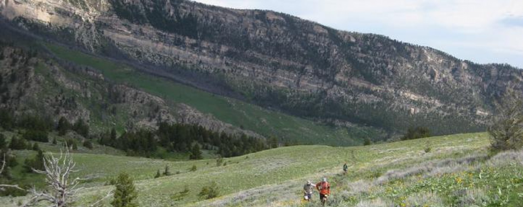
Bighorn Trail Runs offer several distances –  18 miles, 32 miles, 52 miles and 100 miles. The courses are  designed to maximize the exposure of the participants, their families, and race volunteers to an extremely scenic, wild, and primitive area of the geologically unique Bighorn Mountains. 

The course allows maximum flexibility to accommodate a variety of unpredictable weather conditions or adverse course contingency courses that would be aesthetically acceptable to the trail runner.

This race is extremely challenging due to the rugged terrain of the Bighorn Mountains, and has become a favourite among avid trail runners. The course, an out-and-back, is at elevations of up to 10,000 feet, among fields of wildflowers and breathtaking scenery. The majority of the course is on rugged mountain trails and 4-wheel drive roads.
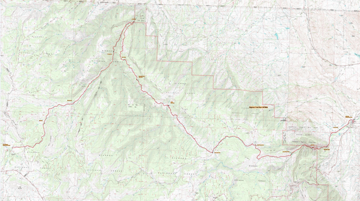
Course highlights

The course is an out-and-back course with the starting point of the 100 mile course on the Tongue River Canyon road approximately 1.25 miles from the Tongue River Canyon trailhead of trail #25 and approximately 3.5 miles from Dayton at the Tongue River fishing access parking area. Access to the start will be along the Tongue River Canyon road from Dayton. The runners will proceed westerly along the gravel Tongue River Canyon road to the Tongue River Canyon trailhead of trail #25. Participants will then ascend Tongue River Canyon on trail #25 to climb out of the canyon on an intersecting trail to Horse Creek Ridge. Runners will descend into the Sheep Creek drainage on trail crossing Sheep Creek to access 4-wheel drive Road #198. They will precede westerly in the Sheep Creek drainage along trail and 4-wheel road #201 to access road #168 (Freeze Out Road) at the head of Camp Creek. Crossing road #168, they will descend the Camp Creek drainage on trail and gravel road #168 to the intersection of 4-wheel drive road #149 with road #168 (Head of the Dry Fork). The participants will then descend the Dry Fork drainage along 4-wheel drive road #149 to its intersection with trail #4 (Dry Fork Trail) at Miller Creek. They will continue northerly on trail #4 to cross the Little Bighorn River footbridge at the intersection of trail #4 with trail #50 (Little Bighorn Trail). From that point (Little Bighorn River footbridge), the runners will ascend the Little Bighorn River drainage on trail #50 crossing road #14 (Devil’s Canyon Road) and descend the Porcupine Creek drainage on trail to the turn-around point at Jaws Trailhead. The runners will subsequently return in the opposite direction on the same course to the starting point in the Tongue River Canyon. From that point, the runners will continue to descend the gravel Tongue River Canyon road to the finish at Scott Park in Dayton.

The 52 mile course begins at Jaws Trailhead and proceeds easterly on trail approximately 1.5 miles where it crosses Forest Service Road #14 (Devils Canyon Road). At this point, the trail joins trail #50 (Little Horn Trail) and starts to descend into the Little Horn drainage. Here is where you start your adventure on the original Little Horn Trail #50. The trail crosses several small creeks as you drop into Willow Creek then Duncum Creek drainages. Panoramic views and splendid seas of wildflowers greet you as the trail descends into the Wagon Box drainage.
After dropping about 1000 feet in 8 miles SPRING MARSH Aid Station #1 awaits your arrival. The supplies are limited there as it is accessible only by foot, so all supplies have been packed in. As the trail descends the Little Bighorn Canyon to Leaky Mountain Creek you might notice a sign about 150 yards after crossing Leaky Creek. At this sign turn and look to your left and you'll see why it was appropriately named Leaky Mountain. As you descend deeper into the canyon excellent views are afforded of the lower parts of the Little Bighorn Canyon and the confluence of the Dry Fork Canyon coming in from the south. Another limited aid station called THE NARROWS Aid Station #2 at 5500 feet and 15 miles into the course is awaiting your arrival. Continuing down to the FOOT BRIDGE Aid Station #3 at 18 miles and 4200 feet you'll find your drop bag at the fully equipped aid station. It is advisable to have dry socks and shoes in your drop bag here. After crossing the Foot Bridge, you begin a major climb up the Dry Fork reaching BEAR HUNTING CAMP Aid Station #4, a limited aid station at mile 21 1/2 and approximately 6300 feet. The course then levels off slightly to the KERNS COW CAMP Aid Station #5 at 28 miles and approx. 6800 feet. This is the course junction where you join the 50 Km course. You'll continue on together climbing up to the HEAD OF THE DRY FORK Aid Station #6 at mile 34 and approx. 7650 feet. This is your second and final drop bag cache. After leaving the aid station the course proceeds up the Freeze Out road, following trails and a gravel road cresting on Camp Creek Ridge at 8,100 feet. It then descends down Sheep Creek drainage to 7,300 feet on a four-wheel drive road. After running about 5.5 miles from the Dry Fork station you will reach the fully supplied UPPER SHEEP CREEK aid station (39 Mile Checkpoint). Next is the summit of Horse Creek Ridge at 8,000 feet, following trails and primitive four-wheel drive roads, which will then drop you into Tongue River Canyon. LOWER SHEEP CREEK aid station at mile 44 1/2 and 5025 feet, is a good place to fill your bottles before entering the sometimes hot canyon below. Continuing on to the TONGUE RIVER aid station at mile 46 1/2 and approximately 4225 feet you will leave the trail and run on a relatively flat gravel road for the remainder of the distance. At about mile 49 is the final aid station, HOMESTRETCH aid station. Continue on and just as you are entering Dayton you will cross the Tongue River on a rustic footbridge. Runners then cross Highway 14 and proceed into town making a left onto 3rd street. Go one block and make a left onto Broadway and into Scott Park where the FINISH awaits you.

The 32M course begins just above the HEAD OF THE DRY FORK aid station and proceeds north and to your left climbing about 500 feet up the 4-wheel drive road. Panoramic views in all directions will greet you as you follow the ridge to Riley Point. If you look down to your left you are viewing the Dry Fork Drainage where later you will be joining the 50 mile course for the remainder of the race. At about 6 miles the course drops steeply for a mile into Miller Creek before reaching the COW CAMP AID STATION, at mile 7 and 6750 feet. This is where you join the 52 mile course.The aid station is fully supplied for the 6 mile gradual climb back to the HEAD OF THE DRYFORK aid station at mile 14. After leaving the aid station the course proceeds up the Freeze Out road, following trails and a gravel road cresting on Camp Creek Ridge at 8,100 feet. It then descends down Sheep Creek drainage to 7,300 feet on a four-wheel drive road. After running about 5 Miles from the Dry Fork station will reach the fully supplied UPPER SHEEP CREEK aid station (18 mile Checkpoint) . Next is the summit of Horse Creek Ridge at 8,000 feet, following trails and primitive four-wheel drive roads, which will then drop you into Tongue River Canyon. Continuing on to the TONGUE RIVER aid station at mile 26.2 and approximately 4375 feet you will leave the trail and run on a relatively flat gravel road for the remainder of the distance. At about mile 29 is the final aid station, HOMESTRETCH aid station. Continue on and just as you are entering Dayton you will cross the Tongue River on a rustic footbridge. Runners then cross Highway 14 and proceed into town making a left onto 3rd street. Go one block and make a left onto Broadway and into Scott Park where the FINISH awaits you.

The 18M course begins at the designated parking area above the HEAD OF THE DRY FORK aid station and proceeds up the Freeze Out road, following trails and a gravel road cresting on Camp Creek Ridge at 8,100 feet. It then descends down Sheep Creek drainage to 7,300 feet on a four-wheel drive road. At about 4 1/2 miles you will reach the fully supplied UPPER SHEEP CREEK aid station. Next is the summit of Horse Creek Ridge at 8,000 feet, following trails and primitive four-wheel drive roads, which will then drop you into Tongue River Canyon. Continuing on to the TONGUE RIVER aid station at mile 12 1/2 and approximately 4375 feet you will leave the trail and run on a relatively flat gravel road for the remainder of the distance. At about mile 15 is the final aid station, HOMESTRETCH aid station. Continue on and just as you are entering Dayton you will cross the Tongue River on a rustic footbridge. Runners then cross Highway 14 and proceed into town making a left onto 3rd street. Go one block and make a left onto Broadway and into Scott Park where the FINISH and picnic gala await you.

Leer más

Mapa de ruta

directions_runStart address: Sheridan,us

flagFinish address: Sheridan,us

Bighorn Mountain Wild and Scenic Trail Runs MAPA DEL RECORRIDO DE

Comentarios

Terrible star_border
Pobre star_border
Ok star_border
Muy bien star_border
Excelente star_border

Se el primero en escribir una reseña para este evento

Bighorn Mountain Wild and Scenic Trail Runs

schedule Canceación de ticket 24H

local_activity Ofertas y descuentos

verified_user Refundable Booking

La información de la carrera se ha encontrado en el sitio web oficial del evento o en otras fuentes de acceso público. Consulta siempre el sitio web oficial para obtener la información más actualizada sobre la carrera. Si falta algún dato o hay algún error, envíanos un correo electrónico para informarnos..