Never Summer 100km & 60km


Join Never Summer 100km & 60km
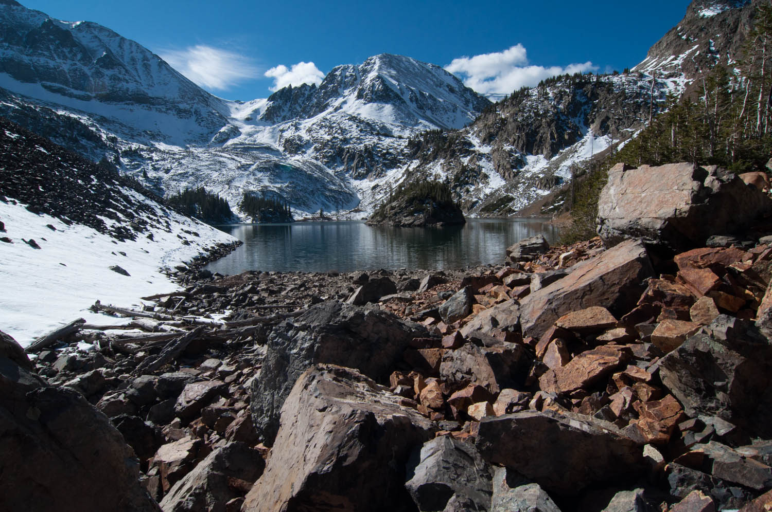
The Never Summer 100km will take place almost entirely within the boundaries of State Forest State Park and run between the Never Summer Mountains on the northern border of Rocky Mountain National Park (RMNP) and the Medicine Bow Mountains to the north of Cameron Pass. The first 20 miles of the race will offer a tour of the peaks and alpine lakes of the northern Never Summer Mountains, before the route crosses Cameron Pass and heads north into the southern Medicine Bow Mountains for more peaks and lakes over the final 40 miles.
This is a mountain race in the truest sense of the term, with extended periods of high alpine ridge running, two alpine peaks, and five alpine lakes visited along the way. When above timberline, you will enjoy huge views of the northern Never Summer Mountains to the south, the stunning peaks of RMNP to the southeast, expansive vistas across North Park to the Park Range above Steamboat Springs to the west, and even north out to Wyoming’s Snowies.
The race covers a huge variety of terrain, from cross country, to jeep and logging roads, to bomber alpine trail, and pretty much everything in between. There are some sections of the course that have seen very little foot traffic in recent years and are rough and overgrown as a consequence; this only adds to the ‘charm’ of the race.
Course highlights
The race will begin at an elevation of 9,100 feet at the Gould Community Center, and will set out in a southeasterly direction on two-track trail heading towards Seven Utes Mountain (11,453′), the alpine summit of which will be gained six miles into the run. From Seven Utes the route crosses a short saddle to connect to the Silver Creek trail which traverses the shoulder of Braddock Peak, before dropping into beautiful Lake Agnes under Mt Mahler and Mt Richthofen and sitting at 10,700′. Runners will follow the northern shoreline of Lake Agnes before dropping down to the Michigan Ditch service road directly below the Nokhu Crags on a short section of scree trail. The Michigan Ditch road will take runners around the northeast ridge of the Nokhu Crags to the American Lakes trail for the ascent up to the stunning American Lakes (11,200′) on the backside of the Crags. Runners will then drop back down and cross the Michigan Ditch following the American Lakes trail out to the Hwy 14 road crossing and aid station.
From the aid station, runners will ascend steeply to North Diamond Peak (11,850′), the high point on the course, from where the route will follow the summit ridge of the Medicine Bow Mountains on faint trail for approximately two miles, before descending west off the ridge on rough jeep road to the Yurt contour trail at approximately 9,600′. The Yurt trail is rough, but will be marked well. Once negotiated, the Yurt trail spits out onto the Ruby Jewel access road which runners take back up the hillside towards Clark Peak for a mile or two before turning north onto the Hidden Valley trail. This trail will take runners back up into the alpine to the high point in Hidden Valley (11,200′), before the descent to beautiful Kelly Lake with views of the Nokhu Crags now far off in the distance to the south. From Kelly Lake the descent down the Kelly Lake trail follows the channel carved out by Kelly Creek through a mix of pine forest and huge old growth aspen groves.
From the end of the Kelly Lake trail, the course follows good forest road north for 1.5 miles to the Clear Lake trail intersection. We loved Clear Lake so much, we decided to throw in a quick 2.2 mile out and back up to the lake. Back-of-the-pack runners will be in for a special treat as they descend back from Clear Lake with an amazing sunset view across North Park to the Park Range.With Clear Lake negotiated, at approximately 44 miles and over 10,000 feet into your day, the meat of the climbing will have been accomplished. As you loop around on the northern perimeter of the course, you’ll be treated to huge views of the mileage you’ve already accomplished, both in the Medicine Bow Mountains and Never Summer Mountains.
Your trek south will parallel the Medicine Bow range in the valley below, beginning on a mix of single track and double track bordered with vibrant Rocky Mountain wildflowers at the 8,500′ low point on the course. At the Canadian aid station (50.1 miles), you will connect with the Northern section of the Yurt trail passing across rough pasture and through pine forest on a slight upward trajectory back to Ruby Jewel Road.
From Ruby Jewel Road, it is fast downhill to the Lumberjack trail and a rolling traverse through a large meadow to the Bockman road crossing and final crew access location. The final climb is a slow grind up to the Gould Mountain saddle on a mix of forest road and rough logging roads. The final descent from the saddle will bring you out to Highway 14, which must be crossed by the Ranger Lakes Campground before the final two groomer miles into the finish.
Bewertungen
Es liegt zu diesem Event keine Bewertungen vor...möchtest du die erste schreiben?
Die Renninformation wurde auf der offiziellen Website der Veranstaltung oder über öffentlich zugängliche Quellen gefunden. Auf der offiziellen Website finden Sie stets die neuesten Informationen zum Lauf. Bitte lassen Sie es uns wissen, wenn Daten inkorrekt sind oder fehlen, indem Sie uns eine E-Mail schreiben.