The Hilary Ultra

Join The Hilary Ultra
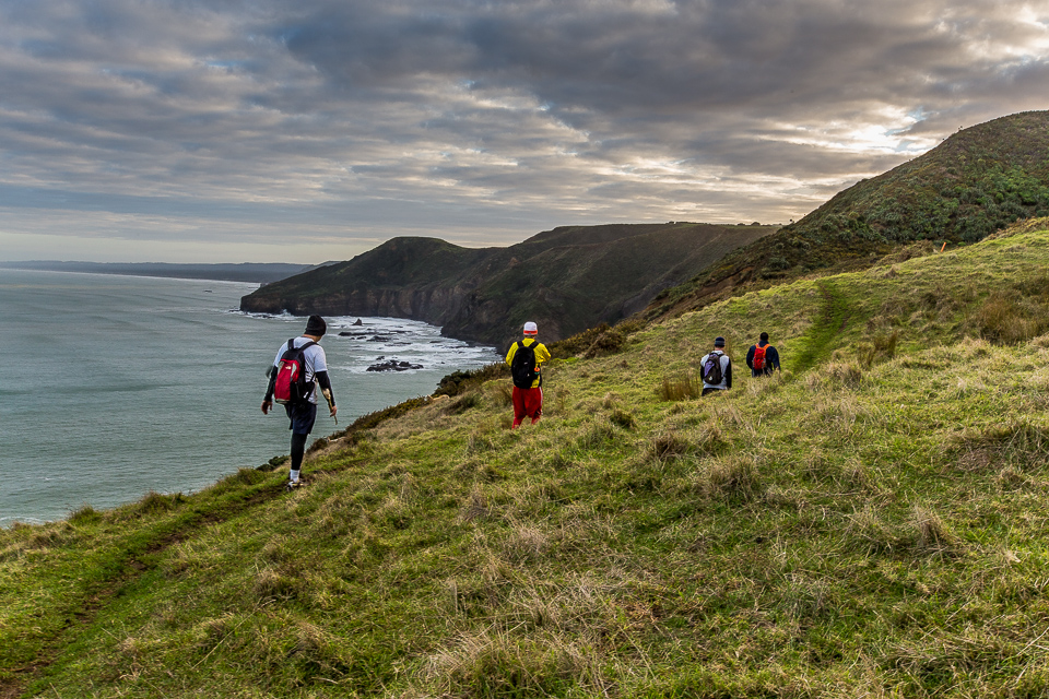
The Hillary Trail is a spectacular multi-day tramping trip through native forest and along the wild coast of the Waitakere Ranges Regional Park. Beginning and ending not far from metropolitan Auckland, this self-guided 70 km trail is a challenging wilderness adventure designed to introduce families and young people, properly prepared, to the joys of multi-day tramping. This is home to the Hillary Trail Run.
The Trail follows a variety of terrain and scenery – many claim a magical pull of the trail and keep coming back for more. Stunning views throughout the trail, rugged West coast beaches, magnificent native bush including the hundreds of year old native Kauri trees. Past large waterfalls and sand dunes, along cliff tops or through marshlands – there is something for everyone.
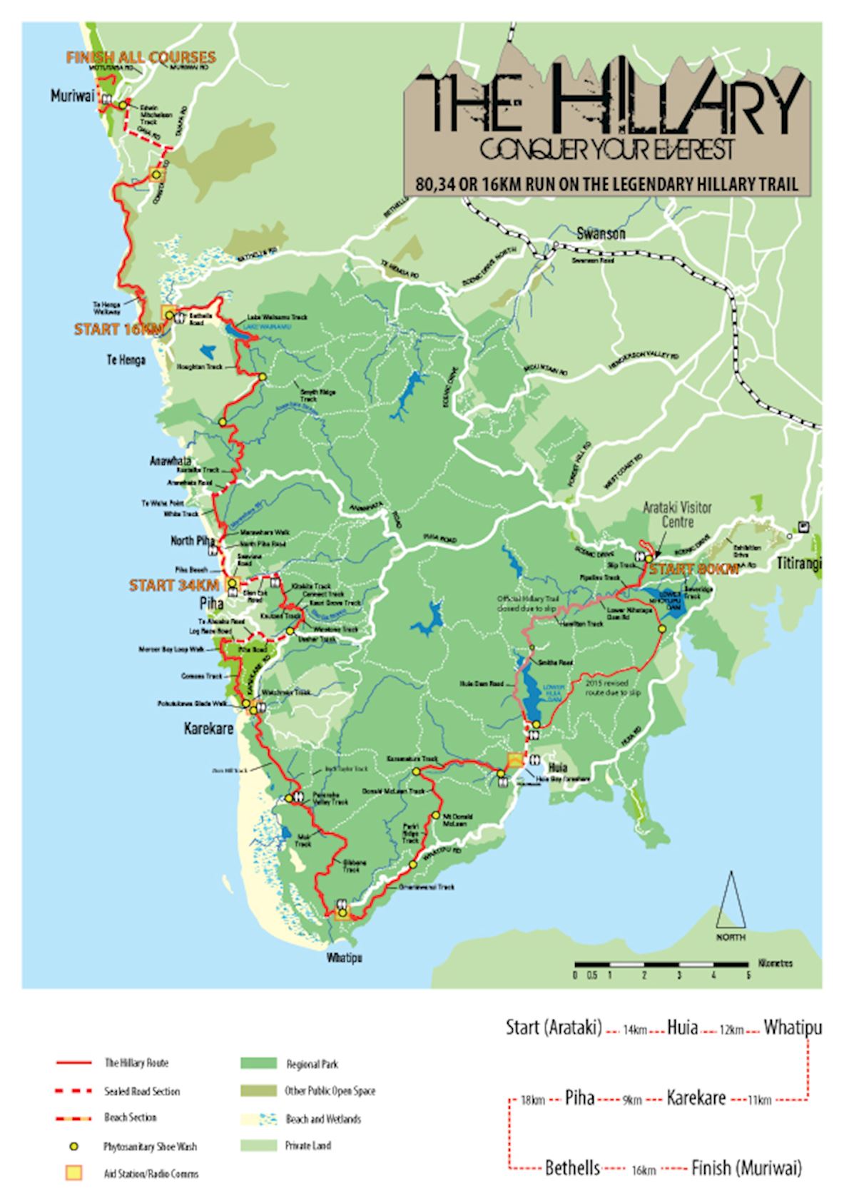
The 80km course follows the Hillary Trail from the Arataki Visitors Centre West of Titirangi all the way to Muriwai, via Huia, Whatipu, Karekare, Piha and Bethells. There is no denying, this is a tough challenge – mentally and physically. With 3,700m climb, the current fastest time is 8 hours 23 minutes. Many would think this seems a long time for 80km but, those that have done would agree – this is no ordinary 80km.
Course highlights
Arataki to Huia (14km)
Starting at the Arataki Visitors Centre you begin with a small 2km loop of the picturesque Nature Trail to spread participants out. Nicely graveled wide tracks of the nature trail are accessed through a tunnel under the main road. The downward leg of this loop is rewarded with a good bite of an uphill back to the start and onto the Hillary Trail proper. From the visitors centre the trail descends for a couple of km on the wide open but bush covered Slip Track. At the bottom of the hill it’s a right turn onto Pipeline Track and pretty soon after the turn your first stream crossing. After Pipeline Track you are on a gravel dam access road. At the end of Pipeline Track you turn left instead of right along the gravel dam access road towards Huia Road. You arrive at the top of a hill and head through the Watercare depot between the sheds and find a small track which takes you into the bush. You join onto Parau Track and follow this all the way up hills, done hills up again and then a awesome downhill towards Huia. You will eventually arrive at the Lower Huia Dam. You run across the top o fteh dam and down the face of it following a sealed road to Huia. In the little village of Huia you turn right at the road intersection and after a steep little climb you head right again to a public farm. The trail weaves through the farm down to the bubbling Karamatura stream which you cross and arrive at the first aid station.
Huia to Whatipu (12km)
After replenishing yourself at the aid station you head out on the Karamatura Track which follows the stream for a while before climbing steeply (over less than 2km) up to the ridgeline just over 400m above sea level (from where the aid station was!). This is a solid climb and one of the bigger ones of the day! You’re welcomed at the top by beautiful, open, mature native forest. Turn left and cruise along the ridgeline towards the Mt Donald McLean trig. Fear not, you don’t climb to the top as you turn right just before it and drop downhill on the Pururi Ridge Track. This is an ancient track used by Maori and logging crews over the centuries. Near the end of this gentle downhill you pop out from the bush for a moment to get an expansive view of Whatipu in the distance. You cross the gravel road and onto Omanawanui Track. This is a crowd favourite as it undulates (not to downplay it – they are mighty big undulations) on sometime razor-edge ridges with big drops directly down to the water of the Manuaku Harbour on one side and the Whatipu valley on the other. After a few big quad killing ups and down you finally descend steeply into the Whatipu Aid station (which is next to an old and unique historic lodge from when Whatipu was a bustling town), all the while, with massive views of the wild west coast beach of Whatipu and the mouth of the Manukau Harbour.
Whatipu to Karekare (11km)
A treat greets you less than a minute after you leave the aid station. A good steady climb on Gibbons Track – the first bit is a good 200m vertical climb up a narrow track weaving between beautiful old trees before flattening out a little to be a gentle climb (and a couple of small relieving downhills) to the top. At the junction at the top you take the left hand track which is a very technical mainly downhill Muir Track. For the confident this technical section is a treat – zig zagging down while making sure your feet land in the right place to stay upright! Muir track drops into the magnificent dinosaur-age like Pararaha valley, past a campsite, through a stream and onto a boardwalk, through the often flooded marsh. The event route varies from the official trail here, taking the right hand Buck Taylor Track instead of heading to the sand dunes, which are a scientific reserve and hence not allowable for an event. This is a steep climb up the southern side of a valley whose beauty can take your breath away, to the track junction where you take a left along Zion Hill Track. This climbs slowly at first and then drops down to the lovely Pohutukawa glade and into Karekare which is the next aid station.
Karekare to Piha (9km)
Following the pattern out of aid stations, after a wee flat section you climb out of Karekare on the Comans Track which features some amazing views of the beach below. You climb next to the cliff tops, through flax forests and past windblown trees. After reaching to 238m above where the aid station was it flattens out a bit you get to the Mercer Bay loop where you can hear the waves crashing below and you get views for miles up and down the coastline. Soon after you arrive at the edge of civilization (barely) – the outskirts of Piha. A few hundred metres of gravel road turns into another few hundred metres of sealed road before hitting Piha Road, the main road into Piha. You carefully cross this very busy road and follow it for a kilometre before ducking back into the sanctuary of the bush taking Usher Track and then racing down Winstone Track into the valley. At the bottom you listen for the roar of the mighty Kitekite falls! You cross the stream just before the top of these falls, do a loop wide around the surrounding cliffs and arrive at the bottom of the falls. Stop and admire the falls as you scramble across the stream under them. Usually this is a place to take quick dip but you are racing right, so a fleeting glance only before a super-fast, graveled track down to the end of Glen Esk Road. On this sealed road you recover from the downhill and head to the next aid station which is about 1.5km away, just past the very tempting Piha Store or Piha Café.
Piha to Bethells (18km)
No climb straight away this time! You get just over a kilometre run along the Piha beach to warm up before a nice section through a dark Nikau palm forest, shallow stream crossing and then a climb up Whites Track. Climbing back up to 200m above sea level in around a kilometre you arrive at the gravel Anawhata Road which you follow for around a km before climbing over the fence and a short farmland section at the start of the Kuataika Track. This gentle farmland is a soothing precursor to the hills on the rest of the Kuataika which mentally destroys many with the mere mention of its name. This track traverses two large valleys and you feel the vertical metres on both. The track is a pleasant, wide clay track with some great bush views and gorgeous stream crossings at the bottom of each valley. After the second steep pinch starts to flatten out and nearly appear flat, you arrive at the top junction. You go left and head down another quite technical downhill to Lake Wainamu. At the lake edge you go right – the long way around! It’s worth it as at the top end of the lake you cross a marsh just downstream from a lovely waterfall. Continuing around the lake you arrive at the walls of the Bethells sand dunes – famous for photos of sliding down on boogie boards or a favourite hill rep training ground for rugby and league teams. You run in the stream below the dunes for a while then pop out on the road into Bethells. Straight across the road and there is the aid station.
Bethells to Muriwai (16km)
From the aid station you have a little jog through open farmland before a small climb to then hop over to O’Neill’s Bay. Now the Te Henga Walkway really starts as you quickly climb to the top of the cliffs. You follow these cliffs for the next 9 kilometres– Muriwai is seen in the distance! At times the track has big drops straight down to the waves below and other times is more inland on sheep tracks which weave in and out of the various gullies along the coast. The entire way is stunning with awe inspiring views that go for miles and miles up the coast. At the north end of the walkway after getting your first sightings of the houses of Muriwai, you start to head inland, climbing to Constable Road, the last few hundred metres on nothing but stairs! Although you will now be close to the finish, the aid station will be a welcoming sight at the top of the stairs. Once refueled you are on a gravel road for about a kilometre then onto the sealed road for just under 2.5km. From here you drop steeply through a wee bush reserve before popping out on another road which you cross straightaway and join the small track out to the Gannet Colony. You ignore the various short lookout tracks out to the colony and try to avoid the busloads of tourists. Head down the track to Muriwai beach which ends the official Hillary Trail but not your race! You still have a short beach jaunt before heading inland over the sand dunes and finally arriving at the finish at the Muriwai Village Green.
Route map
directions_runStart address: 300 Scenic Dr, Nihotupu, Auckland 0604, New Zealand
flagFinish address: Muriwai, New Zealand
评论
Be the first to write a review for this event
赛事信息可以在在赛事的官方网站或通过公开渠道找到。 总是以官方网站上的最新赛事信息作为参考。 如果有任何数据错误或遗失,请通过电子邮件告知我们.