Columbus Trail

Course details
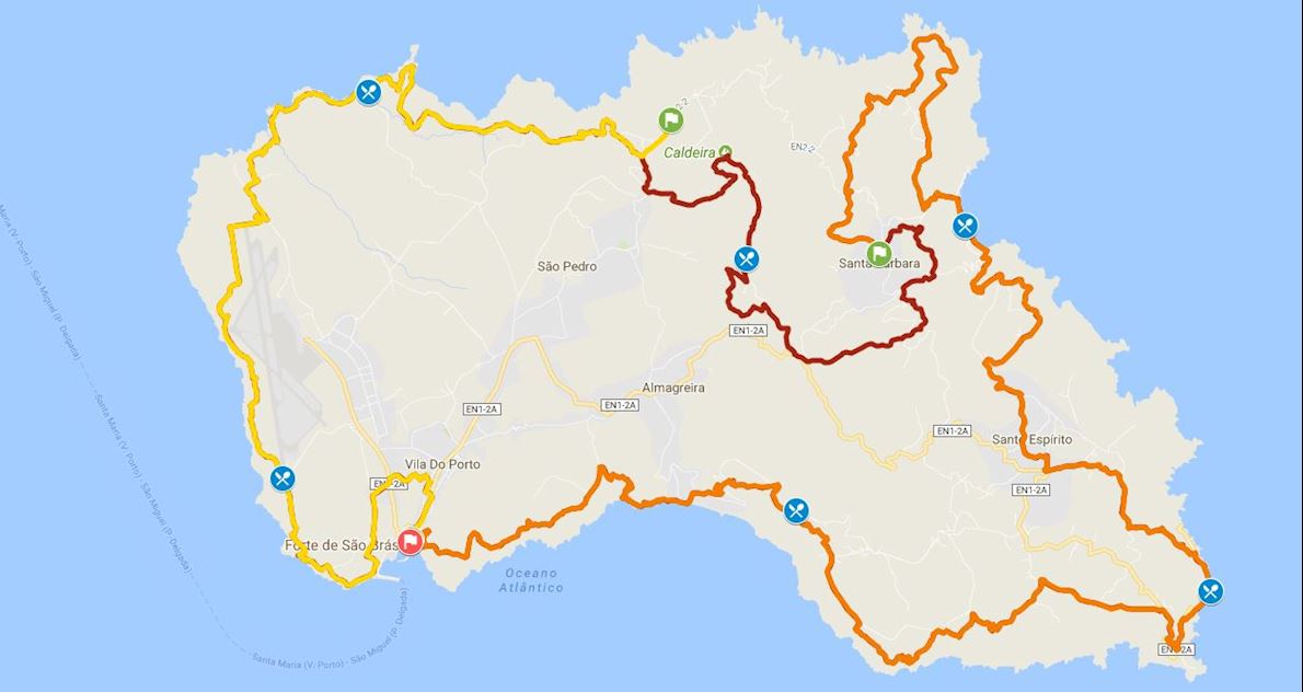
Columbus Grand Trail – (CGT 76 km)
The course begins at São Brás Fortress, and when exiting the village, it goes down to São Francisco stream, continues towards East, ascending until it reaches Pedreira do Campo, a geo-site that aims at the preservation and promotion of a unique geological, palaeontological and volcanological monument. You will be able to see the southern coast of the island. Continue through agricultural lands towards Prainha and Praia Formosa, passing by Forno, and Grutas do Figueirale, by the ruins of two military fortresses and sea fossils.
Leaving the bathing area you will pass by the Nossa Senhora dos Remédios Chapel and from here on you will follow old Praia’s path, an old passage that connects the bay to the parish of Santo Espírito.
The course to Malbusca passes by rural roads, with some sections passing by regional roads. It continues by the coastline towards the locality of Barreiro da Piedade, towards Ponta da Malbusca, with an amazing view over the whole south-western coast, passing by Maloás stream, a geo-site with an impressing geological formation. Continue through agricultural roads of beaten earth track, forest areas and agricultural lands until you reach Cardal.
Between Cardal and the location Norte, continue towards Ponta do Castelo passing by the viewpoint of Tia Raulinha, by Gonçalo Velho lighthouse, at Ponta do Castelo.
From here on, the road goes towards the North, passing by Maia natural swimming pools and continues to Lapa de Baixo.
At the parish of Santo Espírito, the course continues to the North, passing by the parishes of Santo António, Azenha de Cima and finally Azenha de Baixo, through a dirt and stone paved road that will take you to Espigão viewpoint, with a great view over São Lourenço Bay.
When leaving the viewpoint, the road continues through agricultural lands, crossing Salto stream towards São Lourenço bay. It descends then a staircase through vineyards and follows the whole bay until you reach a road that accesses Fajãzinha towards Barreiro.
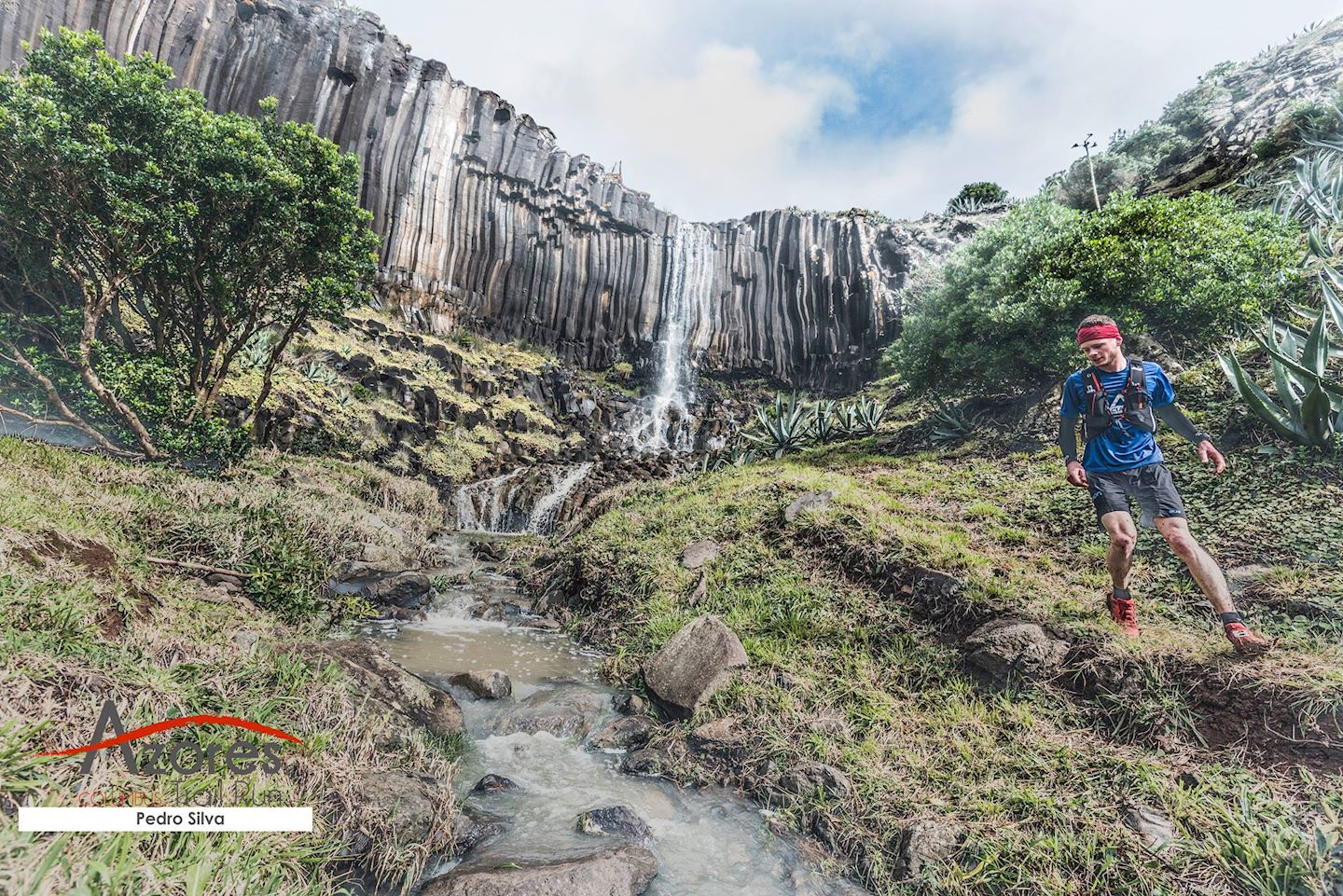
From the centre of the location Norte, you will continue towards the parish of Santa Bárbara, passing by the localities of Lagos, Poço Grande and Boavista, after passing the church of Sagrado Coração de Jesus, towards Poço da Pedreira. From this point on, the course continues towards the South. You will pass by the locality of Arrebentão and by the location Forno, descending by a footpath until you reach Ribeira do Salto stream, where you will be able to see Cai’Água waterfall.
After passing by a fountain, you will continue towards the West by a beaten earth track that connects to the locality of Cruz dos Picos towards North until you reach Pico Alto, the highest point of the island with 587 meters of altitude and rich in endemic vegetation.
At this point you will find a staircase that descends towards Caldeira. This part of the course crosses a forest area where you will find a geodesic landmark with an extraordinary view over the parish of São Pedro.
The course descends towards the regional road, passing by agricultural and forest lands and ending at a fountain.
From the locality of Bananeiras towards Raposo Bay, you will pass by ruins of two watermills, the levada (water channel) that feeds them, and an old wine press.
Continue to the West, towards the geo-site Barreiro da Faneca, the place of the last eruptive phase of the island, where predominates reddish clay and an arid soil. Afterwards, the path leads up to Monte Gordo, where you will find a whaling lookout. The path continues to Ponta dos Frades, towards Anjos.
After contouring Anjos Bay though agricultural lands, you will start descending to the pebble beach, continuing then to the fishing harbour. You will continue to Ribeira do Capitão along a beaten earth track.
Once you reach the end of the airport, you will go to the mouth of Ribeira Seca (stream), which is within a protected area, with a unique view over the islet of Vila do Porto. From here follow along the seafront until you reach Ponta do Malmerendo.
To reach the final stage of the race you must circumvent the slopes, from where you will be able to see the commercial harbour and the centre of Vila do Porto. Follow the beaten earth track that will be halted by the access road to the industrial zone and proceed as far as the historical centre of the village.
Columbus Marathon – (CM 42 km)
The course begins at São Brás Fortress, and when exiting the village, it goes down to São Francisco stream, continues towards East, ascending until it reaches Pedreira do Campo, a geo-site that aims at the preservation and promotion of a unique geological, palaeontological and volcanological monument. You will be able to see the southern coast of the island. Continue through agricultural lands towards Prainha and Praia Formosa, passing by Forno, and Grutas do Figueirale, by the ruins of two military fortresses and sea fossils.
Leaving the bathing area you will pass by the Nossa Senhora dos Remédios Chapel and from here on you will follow old Praia’s path, an old passage that connects the bay to the parish of Santo Espírito.
The course to Malbusca passes by rural roads, with some sections passing by regional roads. It continues by the coastline towards the locality of Barreiro da Piedade, towards Ponta da Malbusca, with an amazing view over the whole south-western coast, passing by Maloás stream, a geo-site with an impressing geological formation. Continue through agricultural roads of beaten earth track, forest areas and agricultural lands until you reach Cardal.
Between Cardal and the location Norte, continue towards Ponta do Castelo passing by the viewpoint of Tia Raulinha, by Gonçalo Velho lighthouse, at Ponta do Castelo.
From here on, the road goes towards the North, passing by Maia natural swimming pools and continues to Lapa de Baixo.
At the parish of Santo Espírito, the course continues to the North, passing by the parishes of Santo António, Azenha de Cima and finally Azenha de Baixo, through a dirt and stone paved road that will take you to Espigão viewpoint, with a great view over São Lourenço Bay.
When leaving the viewpoint, the road continues through agricultural lands, crossing Salto stream towards São Lourenço bay. It descends then a staircase through vineyards and follows the whole bay until you reach a road that accesses Fajãzinha towards Barreiro.
The race ends in the parish of Santa Bárbara, next to the church of Sagrado Coração de Jesus.
Start address: R. Eng. Abel Ferin Coutinho 10, 9500-768 Ponta Delgada, Portugal
Finish address: R. Eng. Abel Ferin Coutinho 10, 9500-768 Ponta Delgada, Portugal
Route
Bewertungen
Es liegt zu diesem Event keine Bewertungen vor...möchtest du die erste schreiben?
Die Renninformation wurde auf der offiziellen Website der Veranstaltung oder über öffentlich zugängliche Quellen gefunden. Auf der offiziellen Website finden Sie stets die neuesten Informationen zum Lauf. Bitte lassen Sie es uns wissen, wenn Daten inkorrekt sind oder fehlen, indem Sie uns eine E-Mail schreiben.


